Atrocity Prevention Lab
The Atrocity Prevention Lab is a project to strengthen innovation, collaboration, and impact of atrocity and conflict prevention work through the integration of spatial methods and technologies. Launched in 2023, this project was established by the Signal Program on Human Security and Technology at the Harvard Humanitarian Initiative.
Harvard Humanitarian Initiative
665 Huntington Ave., Building 1, Office 1113
Boston, MA 02115
About Us
The Signal Program on Human Security and Technology at the Harvard Humanitarian Initiative was founded in 2012. The Progam has worked to advance the safe, ethical, and effective use of information technologies by communities of practice during humanitarian and human rights emergencies through interdisciplinary teams that collaborate with faculty members, international organizations, academic and non-academic research institutes, and professional agencies.
Between 2012 and 2022, the team has focused on four major areas of work, including standards and ethics, remote sensing for crisis response, mass atrocity early warning/early action (EW/EA), and vulnerable populations and mobile technologies. These efforts have produced a growing library of satellite imagery guides, novel geospatial technologies for humanitarian research and response, and several practical guides for the ethical implementation of geospatial technologies and ICT.
As the Signal Program enters a new decade, it continues to build on the successes and lessons learned but has pivoted its objectives and strategies to support localized atrocity and conflict prevention decision-makers through the use of spatial data and methods, more broadly.
Our Team

Erica L Nelson, MD, PhM, MAS is an Emergency Medicine physician who conducts research on the use of geospatial methods for public health and humanitarian response. After graduating from Trinity College Dublin with an PhM in International Peace Studies and Development, she worked as a researcher and policy consultant for organizations serving conflict-affected populations in Nepal, Indonesia, the Balkans, Palestine, Ethiopia, and Sudan. She completed her medical training at the University of Washington, residency at the Harvard-Affiliated Emergency Medicine Residency Program, and an MAS in Spatial Analysis for Public Health at Johns Hopkins University. Currently, she is a physician at the Brigham and Women’s Hospital Emergency Department, an instructor within the Division of Global Emergency Services and Humanitarian Programs in the Department of Emergency Medicine at Harvard Medical School, the co-founder of the Harvard Humanitarian Geospatial Analysis Program and the co-director of the Signal Program at the Harvard Humanitarian Initiative, and the deputy medical director of Team Rubicon.

Gillian Elliott is a GIS analyst, environmentalist, and human rights advocate. After completing her bachelor’s degree with a double major in anthropology and environmental sciences from the University of Virginia, she went on to gain two years of hands-on experience with ArcGIS in her role as a technical support analyst at Esri. Most recently, she received her master’s degree in Austria from the Vienna Master in Applied Human Rights, an interdisciplinary MA program hosted at the University of Applied Arts (Vienna). Here, she wrote her master’s thesis on sea-level rise and potential (forced) migration while connecting it to the international human rights legal framework. Her methods included a spatial analysis in a local setting to identify which homes, and by extension how many people, will likely be directly impacted by projected sea-level rise by 2050 and 2100. Gillian is interested in applications of geospatial methods to human rights issues, including humanitarian crises. Currently she works as the research project coordinator for the Signal Program at HHI, a program which aims to make it easier for frontline organizations to leverage geospatial tools in their work towards anticipating and preventing atrocities.
Madhawa “Mads” Palihapitiya is a conflict early warning expert with over twenty years of experience in atrocities prevention in several global hotspots. He is a practitioner of “third generation” citizen-based conflict early warning with notable academic work in the areas of conflict early warning, technology for non-violence, and religion and the arts for peace building. Over the years, Mads has developed several geospatial early warning tools that emphasize the need to bridge the warning-to-response gap. Mads is also an expert in Mediation/Alternative Dispute Resolution (ADR) methods, particularly ADR research and dispute systems design. He is an expert in evaluation, particularly needs assessment, asset mapping and participatory methods. Currently, Mads is the associate director and research director of the statutory state dispute resolution, Massachusetts Office of Public Collaboration, a senior fellow at the Center for Peace, Democracy, and Development; an adjunct professor at the John W. McCormack Graduate School of Policy and Global Studies at UMass Boston, and a co-convener of the Trust Network.

Godfred (Kofi) Nyarko is the research program manager for the National NGO Program on Humanitarian Leadership at the Harvard Humanitarian Initiative. He also serves as a monitoring and evaluation consultant for the Signal Program. Kofi has a diverse professional background. He served as the country director for Mercy Project Ghana where he fought daily to eradicate slavery from his homeland. Kofi helped liberate over 50 children and reunified them with their families. In past years, Kofi worked in health information management both in the United States and Ghana, including working as a biostatistics assistant at the Cape Coast Teaching Hospital, Ghana, and as a project assistant at the Medical University of South Carolina. Kofi holds a BA in Population and Health from the University of Cape Coast, Ghana, and an MA in International Development Policy with a certificate in Negotiations and Leadership from The University of Chicago. Kofi is interested in organizational effectiveness, particularly within the humanitarian sector.
Drew Boyd has more than a decade of experience in civilian protection, security, humanitarian technology and direct cooperation with at-risk communities. He has worked extensively with human rights defenders around the world, including in the Democratic Republic of the Congo, Iraq, South Sudan, Myanmar, and other conflict zones.
He has provided expert testimony to parliamentary committees working to address mass atrocities and genocide, provided technical and operational guidance to various international organizations, and delivered presentations at global conferences on the subjects of violence prevention and early warning.
Kalu Okigwe is a Graduate Intern with the Harvard Humanitarian Initiative’s Atrocity Prevention and Early Warning Lab. He holds a B.S. in Geography and Environmental Management and is currently pursuing an M.S. in Geographic Information Science at Clark University in Worcester, Massachusetts. His work focuses on GeoAI, environmental risk assessment, and satellite-based analytics. At HHI, he contributes to geospatial research, conflict and disaster monitoring, and the development of early-warning tools that support evidence-based humanitarian and peacebuilding efforts.
Kalu has previously worked in environmental engineering and urban planning and has served on the NASA Earth Science Review Board. He also worked as the Director of Analytics for a consulting firm. His research interests center on applying AI to Earth observation and geospatial data analytics.

Sumina Suwal is a Master’s candidate in Sustainable International Development at Brandeis University whose work focuses on culture, technology, and social change. Her research combines historical-philosophical analysis with computational methods to examine how political and economic systems use data and technology to shape human development. She applies geospatial analytics and machine learning to study conflict dynamics, resource governance, and humanitarian intervention. She has previously worked with think tanks and academic institutions across South Asia, Europe, and the United States on political economy, foreign investment, and technology infrastructure.
Our Vision
Foster a world in which all communities have the capacity to anticipate, prevent, and respond to atrocities.
Our Mission
Strengthen the efficacy and efficiency of atrocity and conflict early warning/early action (EW/EA) work through strategic, evidence-based, and ethical integration of spatial methods, field methods, and novel analytical tools into existing EW/EA decision-support mechanisms and workflows.
Our Modus Operandi
While data ethics and localization strategies have gained traction in humanitarian communities, the emphasis is often on the rights to protection, data privacy and security, and not the need to center under-represented communities and end-users in the development of functional humanitarian technologies.
The gap between theory and practice remains significant. And too often ‘best practices,’ methodological frameworks, and technologies are born of scientific and techno-centric ideals that have little to do with the contextual realities and capacities of those utilizing them. This undermines feasibility, usability and sustainability. Often marginalized and acutely vulnerable sectors of a population are excluded from critical humanitarian technological design and implementation that will directly affect them, leading to exacerbations of those vulnerabilities.
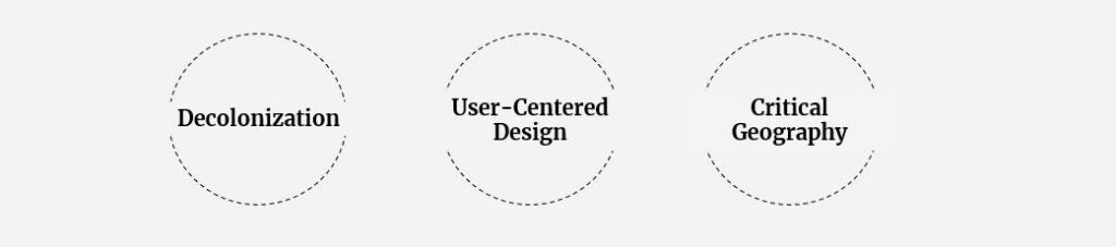
Our work engages user-centric design methods and principles from decolonization and critical geography to understand and fill critical gaps in the use of deployable data for meaningful decision-support along the spectrum of EW/EA actors. While the user-centric methodology does require greater time and resources to create technologies and tools, there is significant evidence from the IT industry and commercial product development supporting its use to increase product performance, exposure, credibility, and uptake, and to decrease the likelihood of producing tools that are irrelevant, inappropriate, or simply not used.
The last thing we as an organization want is to create another spatial algorithm that is published in an article, or another data-driven dashboard that is shipped to an end-user, and then simply collects dust.