Mapping Hope: Rebuilding Lebanon After Conflict
The escalation of the Lebanon conflict in October 2024 left a devastating impact on the country, particularly in the southern regions. The destruction of homes, infrastructure, and public services created an urgent need for accurate data to guide recovery efforts. In response, the Humanitarian OpenStreetMap Team (HOTOSM) launched an ambitious project to map the affected areas, with volunteers mapping approximately 200,000 buildings in the South Lebanon and Nabatieh governorates over the past six months. This effort has been critical in providing a foundation for reconstruction and resilience-building in the region.
The Scale of Destruction and the Need for Mapping
The conflict caused widespread damage across Lebanon, but the southern regions bore the brunt of the destruction. Researchers Corey Scher and Jamon Van Doek found that the estimated total number of likely damaged or destroyed buildings in Lebanon is about 18,500 buildings since 26 September 2023.
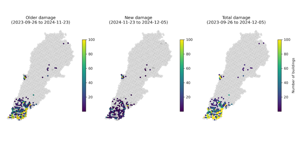
The damage has major consequences to people displaced by the conflict to be able to return to their homes, and for Lebanon to recover. According to the World Bank’s Rapid Damage and Needs Assessment (RDNA) conducted in March 2025, over 30% of residential buildings in South Lebanon were damaged, with many completely destroyed. The report estimates that $1.5 billion will be required for recovery efforts, with a significant portion allocated to housing reconstruction and infrastructure rehabilitation. The mapping efforts by HOTOSM have been instrumental in identifying the most affected areas, enabling aid organizations and government agencies to prioritize resources effectively.
The RDNA report also highlights the damage to critical infrastructure, including schools, hospitals, and water systems. For example, 15% of schools in the southern regions were rendered unusable, disrupting education for thousands of children. The mapping data has been crucial in planning the reconstruction of these facilities, ensuring that communities can regain access to essential service and people can return home permanently
Collaborative Mapping Efforts
To tackle the immense task of mapping the damaged areas, HOTOSM divided the work into 11 distinct projects, each focusing on specific regions within South Lebanon and Nabatieh. This structured approach allowed volunteers to systematically cover the affected areas, ensuring that no community was left behind.
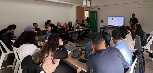
One of the key initiatives in this effort was the organization of mapathons, collaborative events where volunteers come together to map specific areas. The first mapathon was held in January 2025 in coordination with the Lebanon Reforestation Initiative. This event brought together local and international volunteers, who worked tirelessly to map thousands of buildings in a single day. The success of this event demonstrated the power of community-driven initiatives in addressing large-scale challenges. We are thrilled to see growing interest from various institutions, including the Lebanon Reforestation Initiative and Reach Initiative, who have expressed interest in collaborating with us. Additionally, educational institutions like Balamand University and American University of Beirut (Beirut Urban Lab) have invited us to their City Debates event in April 2025 and are interested in hosting a mapathon with us. Furthermore, the Ministry of Culture has invited us to organize a mapathon focused on heritage sites in Lebanon during April 2025. These opportunities highlight the potential for continued collaboration and impact through mapping and data-driven initiatives.
Building Local Capacity for Sustainable Recovery
After the initial mapathon in Lebanon, HOTOSM organized a Training of Trainers (ToT) session for experienced GIS professionals in February 2025. This initiative aimed to equip participants with the tools and methodologies needed to use the HOTOSM platform to ensure the highest of data quality. The trained professionals are now leading mapping efforts and conducting additional training sessions, ensuring that local capacity for mapping and data analysis continues to grow. This focus on capacity building is essential for creating sustainable recovery solutions that empower local communities.
The RDNA report emphasizes the importance of community engagement and local capacity building in the recovery process. By training local professionals and involving community members in OSM and other mapping efforts, HOTOSM is ensuring that the recovery process is inclusive and responsive to the needs of those most affected by the conflict.
The Road Ahead: From Rubble to Resilience
The mapping efforts in South Lebanon are more than just a technical exercise; they are a vital step toward rebuilding lives and communities. The data collected by HOTOSM volunteers is being used to guide reconstruction projects, prioritize aid distribution, and plan for long-term resilience. For example, the mapping data has already been used to identify areas where housing reconstruction is most urgently needed, helping to ensure that displaced families can return to safe and secure homes.
The RDNA report also highlights the importance of disaster risk reduction in the recovery process. By incorporating resilience-building measures into reconstruction projects, such as strengthening buildings to withstand future conflicts or natural disasters, Lebanon can reduce the risk of similar devastation in the future.
A Call to Action
The progress made so far is a testament to the dedication of HOTOSM volunteers and the power of collaborative efforts. However, much work remains to be done. The RDNA report estimates that 50,000 homes still need to be rebuilt, and thousands of families remain displaced. Continued support for mapping and reconstruction efforts is essential to ensure that all communities in South Lebanon can recover and thrive.
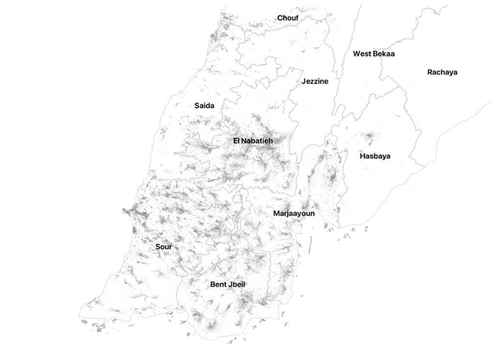
The below map provides a visual representation of the areas covered in the mapping projects, highlighting the scale of the efforts and the progress made so far. It serves as a reminder of the challenges that remain and the importance of continued collaboration in the recovery process.
If you are interested in volunteering, partnering, or supporting our work in Lebanon, contact data@hotosm.org or visit HOT’s Tasking Manager projects in Lebanon.
Humanitarian OpenStreetMap Team’s work in conflict affected areas
This work in Lebanon, sponsored by the H2H Network, is part of HOT’s Conflict & Displacement Program. In communities affected by conflict, remote mapping in OSM allows for safe and efficient data collection in hard to reach areas. As the program grows, HOT aims to connect OSM Lebanon and similar communities affected by war to open source tools, and a global network of OSM, humanitarian, and data experts for a better informed recovery. Read more here: hotosm.org/programs/conflict-displacement.
Said Abou Kharroub is a Local Consultant with Humanitarian OpenStreetMap (HOT) for Lebanon.